Datei:Marine protected areas detailed map.jpg
Zur Navigation springen
Zur Suche springen
Größe dieser Vorschau: 800 × 486 Pixel. Weitere Auflösungen: 320 × 194 Pixel | 640 × 389 Pixel | 1.024 × 622 Pixel | 1.280 × 777 Pixel | 2.560 × 1.554 Pixel | 4.200 × 2.550 Pixel.
Originaldatei (4.200 × 2.550 Pixel, Dateigröße: 1,18 MB, MIME-Typ: image/jpeg)
Beschreibung
| Beschreibung |
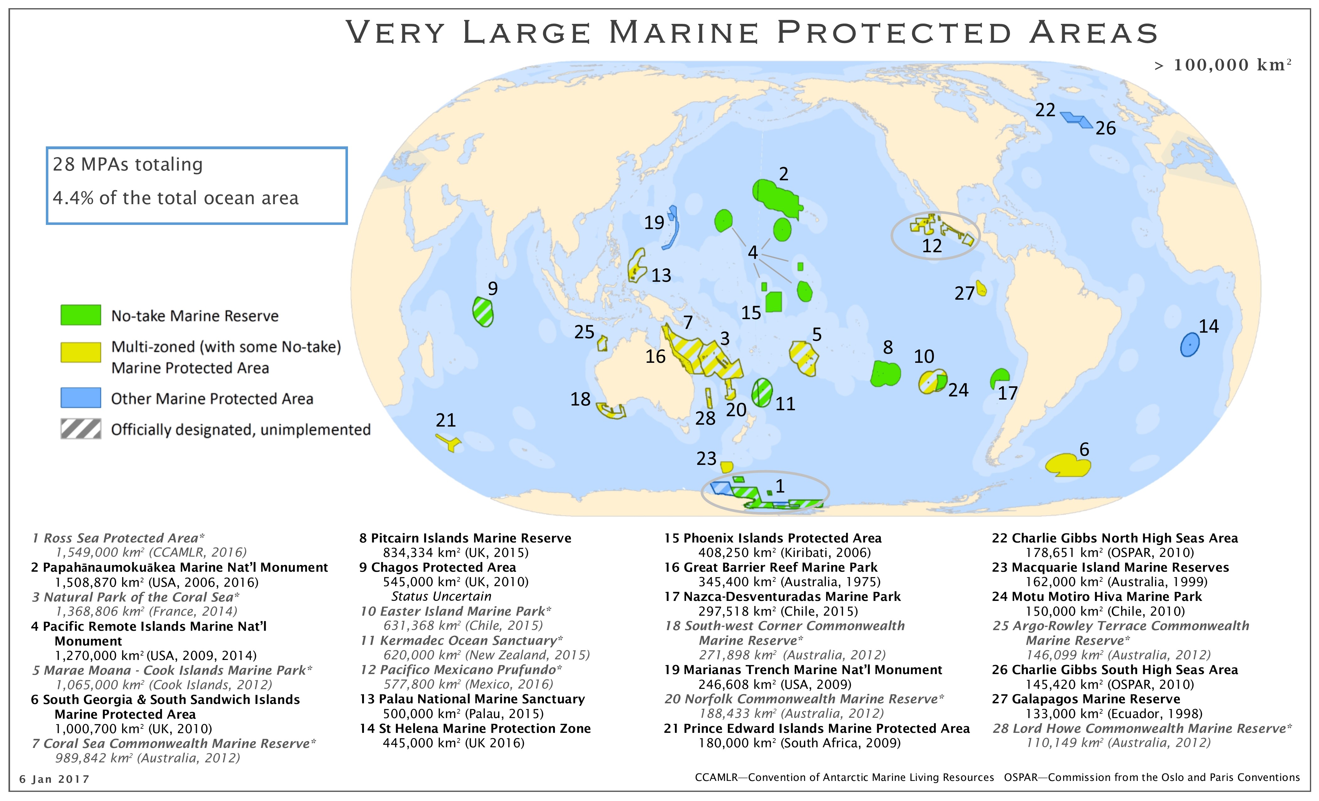
English: Map of the marine protected areas as of 01/2017 |
| Datum | |
| Quelle | http://imperative-mooc.magnetised.net/monitoring-the-oceans-from-space/week-5-oceans-and-us/topic-5a-policy/marine-protected-areas-detailed-map |
| Urheber | MPAtlas.org / Marine Conservation Institute |
| Genehmigung (Weiternutzung dieser Datei) |
|
Lizenz
Diese Datei ist lizenziert unter der Creative-Commons-Lizenz „Namensnennung – Weitergabe unter gleichen Bedingungen 4.0 international“.
- Dieses Werk darf von dir
- verbreitet werden – vervielfältigt, verbreitet und öffentlich zugänglich gemacht werden
- neu zusammengestellt werden – abgewandelt und bearbeitet werden
- Zu den folgenden Bedingungen:
- Namensnennung – Du musst angemessene Urheber- und Rechteangaben machen, einen Link zur Lizenz beifügen und angeben, ob Änderungen vorgenommen wurden. Diese Angaben dürfen in jeder angemessenen Art und Weise gemacht werden, allerdings nicht so, dass der Eindruck entsteht, der Lizenzgeber unterstütze gerade dich oder deine Nutzung besonders.
- Weitergabe unter gleichen Bedingungen – Wenn du das Material wiedermischst, transformierst oder darauf aufbaust, musst du deine Beiträge unter der gleichen oder einer kompatiblen Lizenz wie das Original verbreiten.
Dateiversionen
Klicke auf einen Zeitpunkt, um diese Version zu laden.
| Version vom | Vorschaubild | Maße | Benutzer | Kommentar | |
|---|---|---|---|---|---|
| aktuell | 07:22, 12. Jan. 2017 | | 4.200 × 2.550 (1,18 MB) | wikimediacommons>Hedwig in Washington | {{Information |Description ={{en|1=Map of the marine protected areas as of 10/2016}} |Source =http://imperative-mooc.magnetised.net/monitoring-the-oceans-from-space/week-5-oceans-and-us/topic-5a-policy/marine-protected-areas-detailed-map |Au... |
Dateiverwendung
Die folgende Seite verwendet diese Datei: